


Tactical GPS
Tactical GPS का विवरण
यह जीपीएस एप्लिकेशन आपकी वर्तमान स्थिति से आपके गंतव्य तक असर और दूरी प्रदान करने के लिए उपग्रह डेटा का उपयोग करता है। इसे इंटरनेट एक्सेस की आवश्यकता नहीं है, आप इसे पहाड़ों, रेगिस्तान या समुद्र जैसी जगहों पर उपयोग कर सकते हैं। आप जिस स्थान पर जाना चाहते हैं, बस उसके जीपीएस निर्देशांक दर्ज करें।
GPS संकेतों को सही ढंग से प्राप्त करने के लिए, फ़ोन का आकाश स्पष्ट होना चाहिए।
ये मुख्य विशेषताएं हैं:
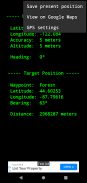
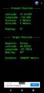
- मोबाइल फोन जीपीएस सेंसर का उपयोग कर अक्षांश, देशांतर और ऊंचाई प्रदर्शित करता है
- भौगोलिक निर्देशांक दशमलव डिग्री में व्यक्त किए जाते हैं
- WGS84 डेटम का उपयोग करता है, वही GPS उपकरणों और Google मैप्स में उपयोग किया जाता है
- पृथ्वी के चुंबकीय क्षेत्र के आधार पर वर्तमान शीर्षक प्रदर्शित करता है। इसे कम्पास के रूप में इस्तेमाल किया जा सकता है (0º = उत्तर, 90º = पूर्व, 180º = दक्षिण, 270º = पश्चिम)
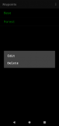
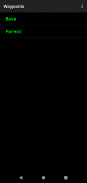
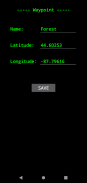
- वेपॉइंट्स की एक सूची स्टोर कर सकते हैं और अपनी वर्तमान स्थिति से लक्ष्य स्थिति तक असर और दूरी प्रदर्शित कर सकते हैं
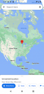
- अन्य एप्लिकेशन के साथ साझा करने की अनुमति देते हुए, Google मानचित्र को लक्ष्य स्थिति भेज सकते हैं। इस विकल्प के लिए इंटरनेट का उपयोग आवश्यक है
- कम बैटरी का उपयोग करता है
- हमेशा 100% मुफ़्त रहेगा
आनंद लेना ! :-)
Tactical GPS - Version 3.00
(18-04-2023)Tactical GPS - एपीके जानकारी
एपीके संस्करण: 3.00पैकेज: org.z3studio.MilitaryGPSLatest Version of Tactical GPS
अन्य संस्करण


Apps in the same category


